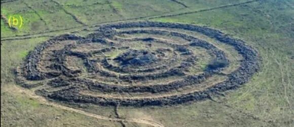
Geodynamic shifts challenge Rujm el-Hiri’s role as an ancient observatory.
A new study by Tel Aviv University and Ben-Gurion University of the Negev reveals groundbreaking findings about the famous Rujm el-Hiri site (known as the “Wheel of Ghosts”) in the Golan Heights. Based on geomagnetic analysis and tectonic reconstruction, the researchers determined that geodynamic movement over 150 million years, at an average rate of 8–15 mm per year, caused significant shifts in the ground, rotating and reorienting it over millennia. This finding challenges the widely held theory that the structure was used as an astronomical observatory, as the original alignment of the walls and entrances does not correspond to celestial observations, as previously hypothesized.
The study was led by a research team headed by Dr. Olga Khabarova and Prof. Lev Eppelbaum of the Department of Geophysics at the Porter School of the Environment and Earth Sciences, Tel Aviv University, in collaboration with Dr. Michal Birkenfeld of the Department of Archaeology at Ben-Gurion University. The article was published in the prestigious journal Remote Sensing.

Left to right: Dr. Olga Khabarova & Prof. Lev Eppelbaum.
The researchers employed geophysical methods and remote sensing techniques to demonstrate that Rujm el-Hiri’s current orientation differs from its original position due to thousands of years of geodynamic shifts. This discovery raises new questions regarding the site’s possible identification as an observatory. The team conducted initial mapping and documentation of the archaeological landscape within 30 kilometers around the Sea of Galilee. It visually analyzed the region to identify typical landscape features associated with historical human activity and the reconstruction of archaeological objects.
According to the research team, “The study was based on calculations of the sky map and aligning the directions of the solstices, equinoxes, and other celestial bodies as they appeared between 2500–3500 BCE, coordinated with the symmetry and entrances of Rujm el-Hiri in its current position. The findings show that the entrances and radial walls during that historical period were entirely different, reopening the question of the site’s purpose”.
The study also provides the first comprehensive mapping of the archaeological landscape surrounding Rujm El-Hiri, using advanced satellite technology. Unique landscape features were identified, including circular structures with 40–90 meters diameters, thick walls, and round enclosures approximately 20 meters in diameter, which appeared to serve agricultural or herding purposes. Dozens of burial mounds (tumuli) were documented in the area, some of which were likely used as storage facilities, shelters, or dwellings, in addition to their traditional role as burial sites.
The researchers conclude: “This new study not only opens a window to understanding Rujm el-Hiri but also enriches our knowledge of ancient life in the Golan Heights and the connections between various archaeological findings in the area”.
